I recently bought a satellite communicator, the DeLorme InReach SE. It can send an SOS, and it’s a two-way communicator, so rescue personnel can tell you they’ve actually received your message.
Of course, you can also use it to text your friends and loved ones, and to receive texts from them. Arbitrary 160-character texts are possible, but on my plan, sending more than 10 a month costs money, so I haven’t done that much. What I have done is send pre-set messages, which are free. I use them to check in (“Everything is ok.”) and to request help in non-life-threatening situations (“I need help.”). I also send them just to myself as a cheap way to track my progress.
Last weekend, I took it out to Source Lake for some snowshoeing. Most of the time, it worked well, although there was a situation where I was under some tree cover, and for about 20 minutes it wouldn’t send. I like that I can give the people who care about me peace of mind (in most situations).
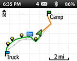
DeLorme announced this week that they are releasing a newer device this May, the DeLorme InReach Explorer. In addition to messaging, the Explorer can also do navigation. For that, the SE needs an Earthmate app on a smartphone.
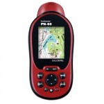
Sounds interesting, but so far, it looks like the Explorer doesn’t do topographic maps, and that’s really what I need. Navigation is nice, but it wouldn’t replace my phone for mapping. Maybe DeLorme didn’t want to compete with its own line of EarthMate GPS devices, which do have topographic maps.
- Navigation on DeLorme InReach Explorer — no topographic maps?
- Topographic map on Delorme EarthMate PN-60
Update
DeLorme customer service confirmed that there are no maps on the DeLorme InReach Explorer itself:
The Explorer model does not have the ability to store maps in itself. It will still need to be paired with a smart device running our Earthmate App for any kind of Topo Maps to be available.


Pingback: Rebuffed by Snow Lake Yet Again | A Concurrent Affair